Where River Water Meets the Sea
See how estuary water mixes and why channels and sediment shift, so you can read these changing boundaries in the landscape.
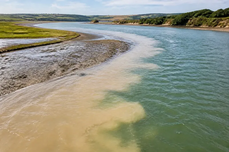
An estuary is not a still bowl where river water simply pours into the sea. Its fresh and salty water meet in moving layers, currents, and swirling patches, while sediment settles in some places and is swept from others. That continual exchange helps explain why an estuary’s channels and banks change shape over time.
How does fresh water meet salt water?
River water usually carries less dissolved salt than seawater, so the two have different densities. Seawater is denser, and in many estuaries it tends to occupy deeper water while fresher river water flows above it. The boundary between them is not a neat, permanent surface. It can blur, tilt, and break into mixing zones as currents and weather change.
Salt water may push upriver along the bed, while river water travels seaward near the surface. This arrangement is called stratification. Where the river’s flow or tidal stirring is strong, the layers mix more thoroughly; where mixing is weaker, a clearer difference between surface and deep water can persist.
There is no single estuary pattern. A narrow, sheltered inlet may retain a sharper division between fresh and salty water. A broad, shallow estuary exposed to strong tidal currents may be stirred more often, blending the water through much of its depth. The amount of river discharge, the shape of the estuary, and the strength and direction of the tide all influence what happens.
Why does the salt boundary move?
The place where fresh water gives way to brackish water and then to seawater shifts rather than sitting at a fixed point. A strong river flow can push salt water toward the mouth. When river flow eases, seawater may extend farther inland, particularly along deeper channels where dense water can move against the surface current.
Tides add another rhythm. As the sea rises and falls, tidal currents carry water into and out of the estuary. The movement can stir the water column, transport salt in both directions, and shift the zone of mixing. Wind and rainfall can add short-lived changes: wind may pile water toward one shore, while rain can swell streams feeding the estuary.
These influences overlap. A salt boundary observed on one visit may not occupy the same position on another, even if the banks look unchanged. Salinity also varies with depth. A surface sample near the mouth may taste or test much less salty than water drawn from a deeper channel nearby.
What does mixing do to sediment?
Rivers carry sediment downstream, from fine clay and silt to coarser sand. The water’s speed determines whether grains remain suspended, settle, or are picked up again. As river flow meets slower or more strongly mixed water, some particles lose momentum and drop toward the bed. Other grains keep moving, especially where currents remain swift.
Fine sediment can behave differently in salty water than it does upstream. Tiny clay particles may clump together as salt changes the chemistry around them. These larger aggregates can settle more readily, forming a moving zone of suspended material. The location and intensity of this zone depend on local water movement; it is not a fixed deposit that permanently blocks the estuary.
Settled sediment can build shallow shoals, mudflats, or bars, while currents scour deeper channels through or alongside them. A channel may deepen where flowing water concentrates, then split or curve around deposits that slow it. Floods, tides, and waves can remobilize material that seemed settled, carrying it elsewhere within the estuary or out toward the coast.
Why do estuary channels and banks change?
A channel is shaped by the balance between water’s ability to move sediment and the supply of sediment available to move. Strong currents can erode the bed or banks. In quieter reaches, particles settle and gradually raise the bed. When one route becomes shallower or obstructed by a deposit, more water may flow through another route, concentrating erosion there.
The banks respond too. Where currents strike a bend, they can wear away the outer bank; on a sheltered inside bend, slower water may leave sediment behind. Vegetation can bind some muddy margins, while exposed or frequently scoured edges may remain more vulnerable to erosion. These local contrasts produce a channel that can meander, branch, narrow, or shift its deepest route.
Human changes can influence the same processes. Dredging removes sediment from a channel, while embankments or barriers can redirect water and alter where it flows. Such interventions may change the pattern of erosion and deposition nearby. Their effects depend on the estuary’s shape and water movement, so a visible change in one reach does not by itself reveal the full cause.
How can you read an estuary’s changing water and channels?
Why can water look cloudy in one part of an estuary?
Cloudiness often comes from fine sediment suspended in the water, though organic material can contribute as well. A cloudy patch may mark a place where currents have stirred the bed or where particles are gathering and settling.
Does salt water always sit beneath fresh water?
No. Denser salt water often occupies deeper layers, but currents, waves, and tidal stirring can mix the water or disrupt that arrangement. Local conditions can also produce patterns that change with depth and time.
Why might a channel shift even without a flood?
Ordinary tidal currents can repeatedly move sediment, building a shoal in one place and scouring a route in another. Many small shifts can alter the preferred path of flow without one dramatic event.
What can a muddy shoal tell you?
It suggests that sediment has settled where the water’s carrying power eased, at least for a time. It does not show that the shoal is permanent; later currents may reshape it or move its sediment elsewhere.
What does a changing estuary look like on the ground?
Imagine arriving at a sheltered inlet after a period of heavy rain and finding a narrow muddy shoal beside the main channel. If river water is flowing strongly, it may carry a cloud of fine particles toward the mouth. As the current slows near a wider reach, some particles settle beside the channel; meanwhile, faster water keeps the deeper route open. The observable result could be a murky plume near the shoal and a clearer, swifter channel alongside it. A later tide or change in river flow may move the plume and reshape the deposit.
To read the scene, look for contrasts rather than assuming every visible feature has one cause. A pale, shallow bar beside darker water may indicate different depths or suspended sediment. A curved bank with fresh-looking exposed mud may suggest recent erosion, while a gently sloping inner bank can collect material. These clues describe current processes, not a forecast of exactly where a channel will go next.
For a practical comparison, return to a safe public viewpoint at different stages of the tide and after different weather, noting cloudiness, exposed mud, and the position of visible channels. Avoid entering tidal flats or crossing channels to inspect them: water can rise or flow through low ground, and apparently firm mud may be soft. A simple field notebook or phone photo taken from the same vantage point can help distinguish a changing water surface from a more lasting shift in the channel pattern.
Why is an estuary never quite finished?
An estuary is continually rearranged because water and sediment keep exchanging places. River flow supplies fresh water and particles; tides bring salt water and stir the mixture; channels focus currents, while quieter margins collect deposits. The balance varies from reach to reach and changes with weather, season, and the shape of the estuary.
That is why a single map or visit captures only one version of the boundary. For anyone asking how an estuary mixes fresh and salt water, the most useful answer includes the moving sediment beneath it: water layers influence currents, currents redistribute grains, and those grains help redraw the channels through which the next tide and river flow will pass.